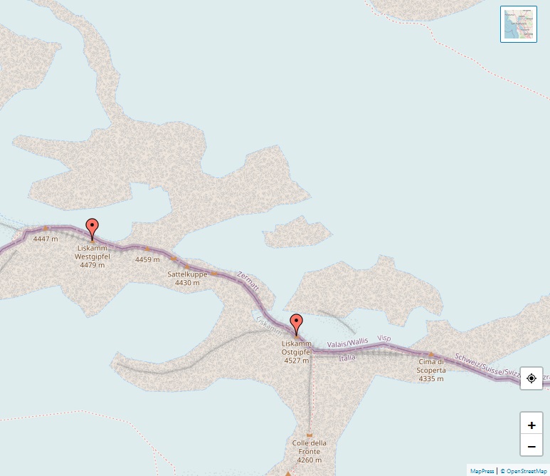
Rimpfischhorn

Alps, map of Rimpfischhorn

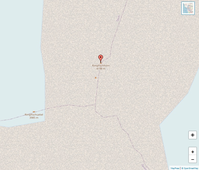
The Rimpfischhorn, standing at 4,199 meters, is a notable mountain in the Pennine Alps of Switzerland, within the Valais region. First ascended on 9 September 1859 by Leslie Stephen, Robert Liveing, and their guides Melchior Anderegg and Johann Zumtaugwald, the Rimpfischhorn has since been a destination for many alpine climbers. Its location in the Pennine … Read more

Alphubel

Alps, map of Alphubel

The Alphubel, rising to 4,206 meters, is a significant mountain in the Swiss Pennine Alps, nestled between the valleys of Zermatt and Saas in the Valais canton. As part of the Allalin subgroup of the Mischabel Group, it boasts a summit with an extensive ice plateau, contributing to the Fee Glacier on its east side. … Read more

Grandes Jorasses

Alps, map of Grandes Jorasses

The Grandes Jorasses, standing at 4,208 meters, is a mountain in the Mont Blanc massif, straddling the border between Haute-Savoie, France, and the Aosta Valley, Italy. This mountain is renowned for its formidable north face, one of the three great north faces of the Alps, along with the Eiger and Matterhorn. This face is especially … Read more

Zinalrothorn

Alps, map of Zinalrothorn

The Zinalrothorn, reaching an elevation of 4,221 meters, is a prominent mountain in the Pennine Alps of Switzerland. Named after the nearby village of Zinal and the German term ‘Rothorn’ meaning Red Peak, it is situated between the Matter valley and the Val d’Anniviers. The Weisshorn and Dent Blanche are its notable neighboring summits. First … Read more

Finsteraarhorn

Alps, map of Finsteraarhorn

The Finsteraarhorn, at 4,274 meters, is not only the highest mountain in the Bernese Alps but also the most prominent peak in Switzerland and the ninth highest in the Alps. Located on the border between the cantons of Bern and Valais, it stands as a significant but less frequented peak compared to its neighbors, the … Read more

Grand Combin

Alps, map of Grand Combin

The Grand Combin, situated in the western Pennine Alps in Valais, Switzerland, is a notable mountain massif reaching 4,314 meters at its highest peak, Combin de Grafeneire. Renowned as one of the highest in the Alps, it comprises several summits over 4,000 meters, including Combin de Valsorey and Combin de la Tsessette. This glaciated massif … Read more

Dent Blanche

Alps, map of Dent Blanche

The Dent Blanche, located in Switzerland’s Pennine Alps in the canton of Valais, stands at 4,357 meters, making it one of the highest peaks in the Alps. Originally known as Dent d’Hérens, it was renamed due to confusion and visibility issues from afar, despite being less snow-capped than its neighbor, Dent d’Hérens. Dent Blanche is … Read more

Matterhorn

Alps, map of Matterhorn

The Matterhorn, a renowned peak in the Alps, stands on the border between Switzerland and Italy. Its summit, at 4,478 meters, makes it one of the highest in the Alps and Europe. Known for its four steep faces and ridges, the Matterhorn is a symbol of the region, overlooking Zermatt in Switzerland and Breuil-Cervinia in … Read more

Weisshorn

Alps, map of Weisshorn

The Weisshorn, standing at 4,506 meters, is a prominent peak in Switzerland’s Pennine Alps, located between the Anniviers and Zermatt valleys in the canton of Valais. First ascended in 1861 by Irish physicist John Tyndall with guides J.J. Bennen and Ulrich Wenger, the Weisshorn is admired for its pyramidal shape and is often considered one … Read more

Lyskamm

Alps, map of Lyskamm

Lyskamm, known in German as Liskamm and historically as Silberbast, is a significant peak in the Pennine Alps, located on the border between Switzerland and Italy. Towering at 4,533 meters, it comprises a five-kilometer-long ridge with two main peaks. Notorious for its challenging conditions, including dangerous cornices and frequent avalanches, Lyskamm has earned the nickname … Read more