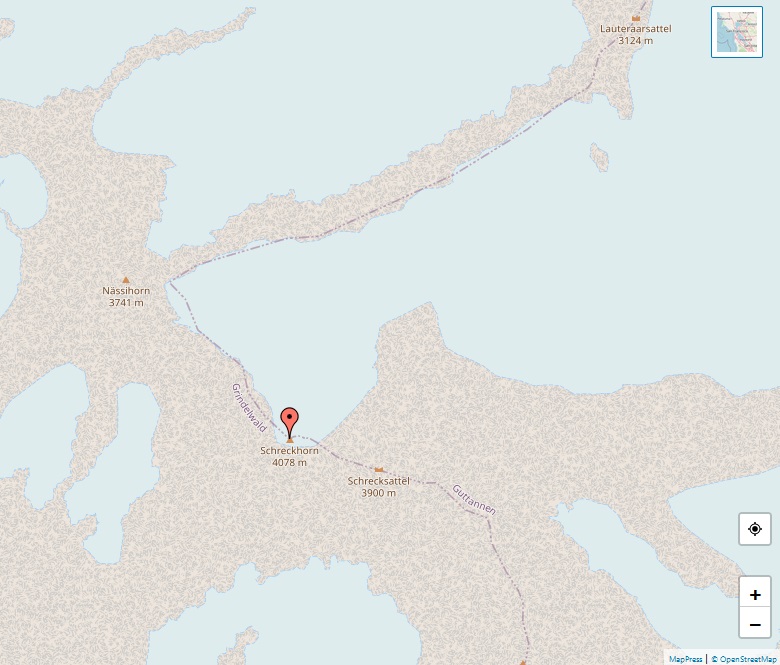
Ober Gabelhorn

Alps, map of Ober Gabelhorn

The Ober Gabelhorn, towering at 4,063 meters, is a striking mountain in the Pennine Alps of Switzerland, located between Zermatt and Zinal. It stands out in the Valais region, particularly in the Zinal valley, flanked by the Dent Blanche to the west and the Zinalrothorn to the north. The mountain is notable for its pyramidal … Read more

Schreckhorn

Alps, map of Schreckhorn

The Schreckhorn, rising to an elevation of 4,078 meters, is a notable mountain in the Bernese Alps and holds the distinction of being the highest peak located entirely within the canton of Berne, Switzerland. Known for its prominent stature, the Schreckhorn is the northernmost peak in the Alps exceeding 4,000 meters, making it a significant … Read more

Barre des Écrins

Alps, map of Barre des Écrins

The Barre des Écrins, standing at 4,102 meters, is a prominent peak in the French Alps and the highest point of the Massif des Écrins and the Dauphiné Alps. Notably, it is the southernmost alpine peak in Europe exceeding 4,000 meters and is the only 4,000-meter peak in France outside the Mont Blanc Massif. Before … Read more

Mönch

Alps, map of Mönch

The Mönch, towering at 4,110 meters, is a prominent mountain in the Bernese Alps of Switzerland. Forming a striking group along with the Eiger and the Jungfrau, the Mönch is visible from great distances and contributes significantly to the iconic skyline of the region. Straddling the border between the cantons of Valais and Bern, the … Read more

Aiguille Verte

Alps, map of Aiguille Verte

The Aiguille Verte, French for “Green Needle,” is a significant peak in the Mont Blanc massif of the French Alps, soaring to an elevation of 4,122 meters. Its first ascent, achieved on 29 June 1865 by Edward Whymper, Christian Almer, and Franz Biner, was a significant event in mountaineering history, occurring just before Whymper’s infamous … Read more

Jungfrau

Alps, map of Jungfrau

The Jungfrau, rising to 4,158 meters, is a majestic peak in the Swiss Alps, renowned as one of the principal summits of the Bernese Alps. It sits astride the cantons of Bern and Valais and forms a part of the stunning trio along with the Eiger and Mönch. The Jungfrau is celebrated not only for … Read more

Breithorn

Alps, map of Breithorn

The Breithorn, peaking at 4,164 meters, is a mountain in the Pennine Alps on the border between Switzerland and Italy. Known for its “broad horn” shape, it lies near the iconic Matterhorn and Monte Rosa. The Breithorn is notable for being one of the most accessible 4,000-meter peaks in the Alps, thanks to the Klein … Read more

Dent d’Hérens

Alps, map of Dent d'Hérens

The Dent d’Hérens, reaching an elevation of 4,174 meters, is a mountain in the Pennine Alps situated on the border between Italy and Switzerland. Lying just west of the iconic Matterhorn, it forms part of the alpine watershed dividing the Swiss canton of Valais and the Italian Aosta Valley. The mountain’s name originates from the … Read more

Strahlhorn

Alps, map of Strahlhorn

The Strahlhorn, standing at 4,190 meters, is a prominent mountain in the Swiss Pennine Alps. It is strategically located south of Saas-Fee and east of Zermatt in the canton of Valais, serving as an important geographic landmark separating the Mattertal and the Saastal. This mountain is part of a range that includes other notable peaks … Read more

Aletschhorn

Alps, map of Aletschhorn

The Aletschhorn, towering at 4,194 meters, is a distinguished peak in the Swiss Alps, located within the Jungfrau-Aletsch region, a UNESCO World Heritage Site. This mountain, second only to the Finsteraarhorn in the Bernese Alps, boasts a unique position entirely within Valais. It is notably positioned between the primary range of the Bernese Alps and … Read more