La Meije

Alps, map of La Meije

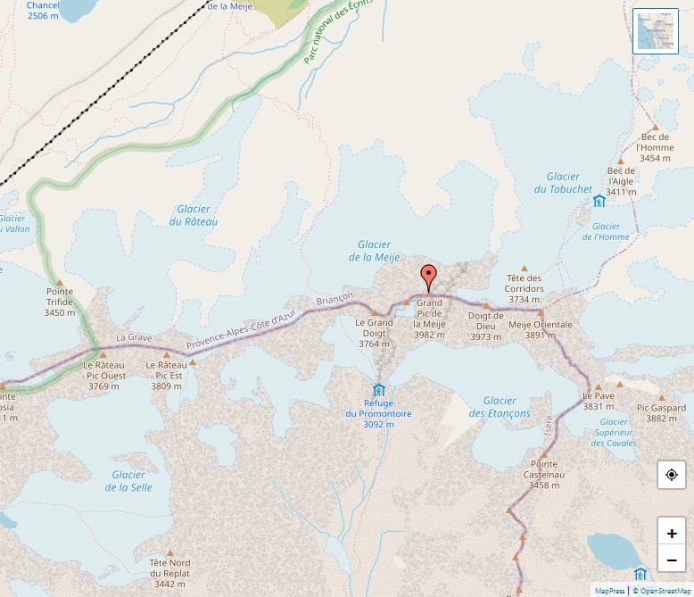
La Meije, soaring to an elevation of 3,984 meters, is a prominent mountain in the Massif des Écrins, situated at the intersection of the Hautes-Alpes and Isère départements in France. This striking mountain, second in height only to the Barre des Écrins within its range, commands the landscape near the village of La Grave, renowned … Read more

Gletscherhorn

Alps, map of Gletscherhorn

The Gletscherhorn, perched at an elevation of 3,983 meters, stands as a distinguished peak within the Bernese Alps, marking the territorial divide between the Swiss cantons of Bern and Valais. This mountain, notably forming the eastern boundary of the Lauterbrunnen Wall, is located to the south of the prominent Jungfrau. A part of the high … Read more

Fletschhorn

Alps, map of Fletschhorn

The Fletschhorn, rising to 3,986 meters, is a notable mountain in the Pennine Alps, positioned between Valais’ Saas and Simplon Valleys in Switzerland. Part of the Weissmies group and situated north of the Lagginhorn, this peak has been a subject of cartographic curiosity, with its height variably mapped at 3,993 meters and more precisely at … Read more

Piz Zupò

Alps, map of Piz Zupò

Piz Zupò, standing at 3,996 meters, is a significant peak in the Bernina Range of the Alps, straddling the border between Switzerland and Italy. This mountain, nestled between the Morteratsch Valley in Graubünden, Switzerland, and the Malenco Valley in Lombardy, Italy, holds the title of being the second highest peak in the Bernina Range, following … Read more

Lagginhorn

Alps, map of Lagginhorn

The Lagginhorn, reaching an elevation of 4,010 meters, is a notable mountain in the Swiss Pennine Alps, positioned near its higher neighbor, the Weissmies, and the slightly lower Fletschhorn. It holds the distinction of being the last four-thousander in the main chain before the Simplon Pass and is the lowest four-thousander in Switzerland. The mountain’s … Read more

Weissmies

Alps, map of Weissmies

The Weissmies, reaching an elevation of 4,017 meters, is a notable peak in the Pennine Alps, situated in the Swiss canton of Valais, near the charming village of Saas-Fee. It holds the distinction of being the easternmost four-thousander in its range. The Weissmies stands out within a massif that divides the Saastal valley to the … Read more

Grünhorn

Alps, map of Grünhorn

The Grünhorn, or Gross Grünhorn, soaring to an altitude of 4,044 meters, is a prominent mountain in the Bernese Alps, Switzerland. It is uniquely positioned on the ridge dividing the Aletsch and Fiescher Glaciers, two of the largest in the Alps. The mountain is flanked by the Gross Wannenhorn to the south and the Gross … Read more

Grosses Fiescherhorn

Alps, map of Grosses Fiescherhorn

The Grosses Fiescherhorn, with an elevation of 4,049 meters, is a significant peak in the Bernese Alps, straddling the border between the Swiss cantons of Bern and Valais. It’s a part of the Fiescherhorn massif, which also includes the Hinteres Fiescherhorn and the Kleines Fiescherhorn, known as the Ochs. The mountain, primarily known for its … Read more

Piz Bernina

Alps, map of Piz Bernina

Piz Bernina, standing at 4,048.6 meters, is the highest mountain in the Eastern Alps and a dominant feature of the Bernina Range in the Rhaetian Alps. Located in the Swiss canton of Graubünden, near the famed resort of St. Moritz in the Engadin valley, it is unique as the most easterly Alpine mountain exceeding 4,000 … Read more

Gran Paradiso

Alps, map of Gran Paradiso

The Gran Paradiso, reaching an elevation of 4,061 meters, is a prominent mountain in the Graian Alps of Italy. As the only peak exceeding 4,000 meters entirely within Italian territory, it holds a unique position in the alpine landscape. Located between the Aosta Valley and Piedmont, it forms part of the Gran Paradiso National Park, … Read more